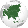
Imådje:Asia (orthographic projection).svg

Fitchî d’ oridjinne (Fitchî SVG, finté di 541 × 541 picsels, grandeu: 557 Ko)

Discrijhaedje
| DiscrijhaedjeAsia (orthographic projection).svg |
العربية: الخريطة الهجائية لآسيا English: Asia |
||||
| Date | |||||
| Sourdant |
National Geographic. Map by Ssolbergj
|
||||
| Oteur | Koyos + Ssolbergj | ||||
| Ôtès modêyes |
العربية: الرجاء، قراءة الميثاق.
বাংলা: দয়া করে, রীতিনীতিটি পড়ুন।
Deutsch: Bitte lies die Konventionen.
English: Please, read the conventions.
Español: Por favor, lea las convenciones.
Filipino: Paki-basa ang mga kumbensyon.
Français : S'il vous plaît, lisez les conventions.
हिन्दी: कृपया सभागमों को पढ़ लें.
Bahasa Indonesia: Silakan, baca konvensi.
Italiano: Si prega di leggere le convenzioni.
日本語: 規約をご確認ください。
ქართული: გთხოვთ, გაეცნოთ კონვენციებს.
Македонски: Ве молиме, прочитајте ги општоприфатените правила.
Português: Por favor, leia as convenções.
Русский: Пожалуйста, прочитайте соглашения.
Tagalog: Paki-basa ang mga kumbensyon.
Українська: Будь ласка, прочитайте конвенції.
Tiếng Việt: Hãy đọc công văn trước khi đăng.
中文(繁體):請檢視常規
中文(简体):请查看常规
|
||||
| SVG information InfoField |
Licince

|
Vos avoz l’ droet di rcopyî, di spåde et di rcandjî ci documint ci sorlon çou k’ est di dins l’ GNU Free Documentation License modêye 1.2 u les cenes d’ après eplaidêyes pal Free Software Foundation, sins hagnons nén candjåves, sins l’ tecse del prumire pådje di coviete eyet sins l’ tecse del dierinne pådje di coviete. Gn a-st on egzimpe del licince divins li hagnon k’ a l’ tite GNU Free Documentation License.http://www.gnu.org/copyleft/fdl.htmlGFDLGNU Free Documentation Licensetruetrue |
- Vos estoz libe :
- di pårtaedjî – di rcopyî, di rispåde eyet di rdiner cisse ouve ci
- di rdjårber – di candjî ciste ouve
- Avou les condicions ki shuvèt :
- atribucion – Vos dvoz dner les racsegnes so l’ oteur ki vont bén, diner on loyén eviè l’ licince eyet mete si des candjmints ont stî fwaits. Vos ploz fé çoula di tote sôre di manires, mins nén tot djant ki l’ oteur vs aspale udonbén asprouve l’ uzaedje ki vos nd e fjhoz.
- pårtaedje a l’ idintike – Si vs candjîz u si vs eployîz ciste ouve ci po dnè fé ene ôte, vos dvoz mete vost ovraedje dizo l’ minme licince u ene licince ki va avou l’ cene di l’ ouve d’ oridjinne.
| Annotations InfoField | This image is annotated: View the annotations at Commons |
India
Sri Lanka
Russia
Mongolia
China
Africa
Oceania
South Korea
North America
Europe
North Korea
Japan
Pakistan
Saudi Arabia
Kazakhstan
Papua New Guinea
Indonesia
Nepal
Iran
Cyprus
Kamchatka
Hokkaido
Cambodia
Turkey
Afghanistan
Bhutan
Philippines
Malaysia
Thailand
Vietnam
Légendes
statut des droits d'auteur français
sous droit d'auteur français
licence français
Licence de documentation libre GNU français
date de fondation ou de création français
15 måss 2009
type MIME français
image/svg+xml
somme de contrôle français
172f5e66318d09590c698956d4edb40320c8ce53
taille des données français
570 850 octet
hauteur français
541 picsel
largeur français
541 picsel
Istwere do fitchî
Clitchîz so ene date ey ene eure po vey kimint ki l’ fitchî esteut adon.
| Date/Eure | Imådjete | Grandeur | Uzeu | Comintaire | |
|---|---|---|---|---|---|
| asteure | 29 djulete 2023 à 18:11 |  | 541 × 541 (557 Ko) | Bennylin | synchronize with File:Southeast Asia (orthographic projection).svg. Source: File:United Nations geographical subregions.png |
| 18 måss 2023 à 00:57 |  | 541 × 541 (496 Ko) | Golden Mage | A change to the map of Asia will first face debate from others. Hence, a change to the commonly accepted map of Oceania cannot be made without a wider consensus. | |
| 17 måss 2023 à 03:44 |  | 541 × 541 (557 Ko) | Kwamikagami | the Weber line divides Asian from Oceanic Wallacea | |
| 4 setimbe 2022 à 19:29 |  | 541 × 541 (496 Ko) | Рагин1987 | Socotra repainted | |
| 4 setimbe 2022 à 17:20 |  | 541 × 541 (492 Ko) | Рагин1987 | Final edit | |
| 4 setimbe 2022 à 12:43 |  | 541 × 541 (446 Ko) | Рагин1987 | Correction | |
| 31 awousse 2022 à 13:13 |  | 2 048 × 2 048 (1,04 Mo) | Рагин1987 | Small correction (Socotra Island is geologically closer to Africa) | |
| 13 decimbe 2019 à 17:59 |  | 541 × 541 (242 Ko) | Goran tek-en | Added border for South Sudan as requested by {{u|Maphobbyist}} | |
| 13 fevrî 2019 à 10:16 |  | 541 × 541 (161 Ko) | عبد الله | Reverted to version as of 16:47, 19 September 2016 (UTC) | |
| 13 fevrî 2019 à 10:11 |  | 512 × 512 (120 Ko) | عبد الله | إزاة خطوط زعجة |
Eployaedjes do fitchî
I n’ a nole pådje k’ eploye ci fitchî ci.
Eployaedje tot avå do fitchî
Les ôtes shuvants wikis eployèt c’ fitchî ci :
- Eployaedje so ab.wikipedia.org
- Eployaedje so ace.wikipedia.org
- Eployaedje so ady.wikipedia.org
- Eployaedje so af.wikipedia.org
- Afrika
- Asië
- Europa
- Filippyne
- Irak
- Israel
- Japan
- Noord-Amerika
- Suid-Amerika
- Volksrepubliek China
- Thailand
- Singapoer
- Maleisië
- Afghanistan
- Sjabloon:Kontinente
- Bangkok
- Katar
- Taipei
- Indië
- Rusland
- Oesbekistan
- Hoofstad
- Lys van hoofstede
- Siprus
- Armenië
- Sjabloon:Lande van Asië
- Iran
- Egipte
- Wikipedia:Sjabloon
- Turkmenistan
- Wikipedia:Lys van sjablone
- Britse Indiese Oseaangebied
- Suid-Korea
- Noord-Korea
- Antarktika
- Beijing
- Gondwana
- Eurasië
- Laurasië
- Kategorie:Lande in Asië
- Libanon
- Jerusalem
- Azerbeidjan
- Bahrein
Loukîz di pus so l’ eployaedje totavå di ci fitchî ci.
Meta-dnêyes
Ci fitchî cial a des infôrmåcions di rawete, motoit bén radjoutêyes pa l’ aparey foto limerike ou l’ sicanrece eployeye po fé l’ imådje.
Si l’ imådje a stî candjeye dispoy adon, i s’ pout ki sacwants detays ni corespondexhe pus totafwait.
| Lårdjeur | 541.48 |
|---|---|
| Hôteur | 541.48 |


