Imådje:Geographic distribution of Bengali language.png

Le contenu de la page n’est pas pris en charge dans d’autres langues.
Èn årtike di Wikipedia.

Fitchî d’ oridjinne(2 806 × 2 080 picsels, groxheur do fitchî: 1,36 Mo, del sôre "MIME": image/png)

Commons logo
Commons logo
Ci fitchî ci provént d’ Wikimedia Commons ; si pout i esse eployî divins des ôtes pordjets Wiki. Li discrijhaedje di si pådje di discrijhaedje låvå est håynêye cial ådzo.

Discrijhaedje

Discrijhaedje
Ελληνικά: Γεωγραφική κατανομή της Βεγγαλικής Γλώσσας ανά επαρχία της Ινδίας και στο Μπανγκλαντές, τα χρώματα στις επαρχίες ποικίλουν ανάλογα με το ποσοστό ομιλητών (δεδομένα απογραφής 2011). Παράγωγο του αρχείου India district map (de-facto).svg.
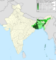
English: Geographic distribution of Bengali language in India and Bangladesh. The map covers each district of India and the five shades of green show the percentage of Bengali language speakers in each district. Source: Indian census 2011. Feel free to enrich the map with data for more Indian districts, or fix any mistakes. Derivative of the file India district map (de-facto).svg.
Date
Sourdant Prôpe ovraedje
Oteur NikosLikomitros

Licince

w:fr:Creative Commons
atribucion pårtaedje a l’ idintike
Vos estoz libe :
  • di pårtaedjî – di rcopyî, di rispåde eyet di rdiner cisse ouve ci
  • di rdjårber – di candjî ciste ouve
Avou les condicions ki shuvèt :
  • atribucion – Vos dvoz dner les racsegnes so l’ oteur ki vont bén, diner on loyén eviè l’ licince eyet mete si des candjmints ont stî fwaits. Vos ploz fé çoula di tote sôre di manires, mins nén tot djant ki l’ oteur vs aspale udonbén asprouve l’ uzaedje ki vos nd e fjhoz.
  • pårtaedje a l’ idintike – Si vs candjîz u si vs eployîz ciste ouve ci po dnè fé ene ôte, vos dvoz mete vost ovraedje dizo l’ minme licince u ene licince ki va avou l’ cene di l’ ouve d’ oridjinne.

Légendes

Ajoutez en une ligne la description de ce que représente ce fichier
Geographic distribution of Bengali language in India and Bangladesh. The map covers each district of India and the five shades of green show the percentage of Bengali language speakers in each district. Source: Indian census 2011.

Éléments décrits dans ce fichier

mostere

créé par français

Valeur sans élément de Wikidata

26 djun 2022

type MIME français

image/png

Istwere do fitchî

Clitchîz so ene date ey ene eure po vey kimint ki l’ fitchî esteut adon.

Date/EureImådjeteGrandeurUzeuComintaire
asteure2 djulete 2022 à 15:05Imådjete pol modêye do 2 djulete 2022 à 15:052 806 × 2 080 (1,36 Mo)NikosLikomitrosA few districts of Arunachal Pradesh have a notable Bengali presence above of 1%, probably part of the Indian efforts to increase its presence in the region.
1 djulete 2022 à 16:55Imådjete pol modêye do 1 djulete 2022 à 16:552 806 × 2 080 (1,36 Mo)NikosLikomitrosTwo extra fixes.
1 djulete 2022 à 16:53Imådjete pol modêye do 1 djulete 2022 à 16:532 806 × 2 080 (1,36 Mo)NikosLikomitrosMinor fixes.
1 djulete 2022 à 16:44Imådjete pol modêye do 1 djulete 2022 à 16:442 806 × 2 080 (1,36 Mo)NikosLikomitrosNow, this map covers all districts of India. Includes also extra information and a new colour key. The basemap is from Distribution_of_Jats_in_South_Asia.png.
26 djun 2022 à 21:09Imådjete pol modêye do 26 djun 2022 à 21:091 902 × 2 048 (1 002 Ko)NikosLikomitrosUploaded own work with UploadWizard

I n’ a nole pådje k’ eploye ci fitchî ci.

Eployaedje tot avå do fitchî

Les ôtes shuvants wikis eployèt c’ fitchî ci :

Meta-dnêyes