
Imådje:Morina ruins.jpg

Grandeur do préveyaedje: 800 × 538 picsels. Ôtès fintés: 320 × 215 picsels | 640 × 431 picsels | 1 024 × 689 picsels | 1 280 × 862 picsels | 2 560 × 1 723 picsels | 5 246 × 3 531 picsels.
Fitchî d’ oridjinne (5 246 × 3 531 picsels, groxheur do fitchî: 12,93 Mo, del sôre "MIME": image/jpeg)
Ci fitchî ci provént d’ Wikimedia Commons ; si pout i esse eployî divins des ôtes pordjets Wiki. Li discrijhaedje di si pådje di discrijhaedje låvå est håynêye cial ådzo.
Discrijhaedje
| Discrijhaedje |
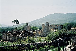
English: Ruins near Morina in the White Drin valley, at the border between Albania and Kosovo. A nearby village is called Planeja, the mountain to the right is called Pastrik. Taken in summer 2001 from a KFOR tank.
These buildings may have been destroyed in the attack, mentioned in the following quote: FOREIGN & COMMONWEALTH OFFICE, LONDON, JUNE 1999 23-24 May |
||
| Date | |||
| Sourdant | Prôpe ovraedje | ||
| Oteur |
|
| Lieu de la prise de vue | | Voir cet endroit et d’autres images sur : OpenStreetMap |
|---|
Moi, en tant que détenteur des droits d’auteur sur cette œuvre, je la publie sous les licences suivantes :

|
Vos avoz l’ droet di rcopyî, di spåde et di rcandjî ci documint ci sorlon çou k’ est di dins l’ GNU Free Documentation License modêye 1.2 u les cenes d’ après eplaidêyes pal Free Software Foundation, sins hagnons nén candjåves, sins l’ tecse del prumire pådje di coviete eyet sins l’ tecse del dierinne pådje di coviete. Gn a-st on egzimpe del licince divins li hagnon k’ a l’ tite GNU Free Documentation License. |
Ce fichier est disponible selon les termes de la licence Creative Commons Attribution 3.0 Non transposée.
- Vos estoz libe :
- di pårtaedjî – di rcopyî, di rispåde eyet di rdiner cisse ouve ci
- di rdjårber – di candjî ciste ouve
- Avou les condicions ki shuvèt :
- atribucion – Vos dvoz dner les racsegnes so l’ oteur ki vont bén, diner on loyén eviè l’ licince eyet mete si des candjmints ont stî fwaits. Vos ploz fé çoula di tote sôre di manires, mins nén tot djant ki l’ oteur vs aspale udonbén asprouve l’ uzaedje ki vos nd e fjhoz.
Voz ploz tchoezi l’ licince ki vos vloz eployî.
Istwere do fitchî
Clitchîz so ene date ey ene eure po vey kimint ki l’ fitchî esteut adon.
| Date/Eure | Imådjete | Grandeur | Uzeu | Comintaire | |
|---|---|---|---|---|---|
| asteure | 7 måss 2010 à 14:11 | | 5 246 × 3 531 (12,93 Mo) | Watchduck | Reverted to version as of 16:04, 13 December 2009 |
| 14 decimbe 2009 à 20:48 |  | 5 163 × 3 431 (12,44 Mo) | Watchduck | color correction | |
| 13 decimbe 2009 à 16:04 |  | 5 246 × 3 531 (12,93 Mo) | Watchduck | There was a black border rest on the left side. | |
| 13 decimbe 2009 à 15:57 |  | 5 258 × 3 531 (12,45 Mo) | Watchduck | {{Information |Description={{en|1=Ruins near Morina in the White Drin valley, at the border between Albania and Kosovo. Taken in summer 2001 from a KFOR tank.}} |Source={{own}} |Author=[[U |
Eployaedjes do fitchî
I n’ a nole pådje k’ eploye ci fitchî ci.
Eployaedje tot avå do fitchî
Les ôtes shuvants wikis eployèt c’ fitchî ci :
- Eployaedje so cs.wikipedia.org
- Eployaedje so de.wikipedia.org
- Eployaedje so en.wikipedia.org
- Eployaedje so en.wikiversity.org
- Eployaedje so fr.wikipedia.org
- Eployaedje so id.wikipedia.org
- Eployaedje so pl.wikipedia.org
- Eployaedje so pt.wikipedia.org
- Eployaedje so ru.wikipedia.org
- Eployaedje so sh.wikipedia.org
- Eployaedje so sq.wikipedia.org
- Eployaedje so sr.wikipedia.org
- Eployaedje so te.wiktionary.org
- Eployaedje so www.wikidata.org
- Eployaedje so zh.wikipedia.org