
Imådje:Umbria et Picenum.JPG
I n’ a nén di pus grande finté.
Umbria_et_Picenum.JPG (545 × 538 picsels, groxheur do fitchî: 108 Ko, del sôre "MIME": image/jpeg)
Ci fitchî ci provént d’ Wikimedia Commons ; si pout i esse eployî divins des ôtes pordjets Wiki. Li discrijhaedje di si pådje di discrijhaedje låvå est håynêye cial ådzo.
Discrijhaedje
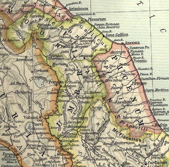
Map of Umbria et Picenum during the Roman period.
Extracted and adapted from The Historical Atlas by William R. Shepherd, 1911.
Original image is at http://www.lib.utexas.edu/maps/historical/shepherd_1911/shepherd-c-026-027.jpg
Licince
Ce document est dans le domaine public aux États-Unis. Ceci s'applique aux travaux des États-Unis où le copyright a expiré, souvent parce que sa première publication s'est produite avant le 1er janvier 1929. Voir cette page pour davantage d'explication.
|
 | |
 |
Cette image peut ne pas être dans le domaine public en dehors des États-Unis (ceci s'applique particulièrement au Canada, en Chine (pas Hong Kong, Macao, ni Taïwan), en Allemagne ou en Suisse). Le créateur et l'année de la publication sont l'information essentielle et doivent être fournis.
|
Istwere do fitchî
Clitchîz so ene date ey ene eure po vey kimint ki l’ fitchî esteut adon.
| Date/Eure | Imådjete | Grandeur | Uzeu | Comintaire | |
|---|---|---|---|---|---|
| asteure | 1 djulete 2007 à 07:54 | | 545 × 538 (108 Ko) | Accurimbono | == Summary == Map of Umbria et Picenum during the Roman period. Extracted and adapted from ''The Historical Atlas'' by William R. Shepherd, 1911. Original image is at http://www.lib.utexas.edu/maps/historical/shepherd_1911/sheph |
Eployaedjes do fitchî
I n’ a nole pådje k’ eploye ci fitchî ci.
Eployaedje tot avå do fitchî
Les ôtes shuvants wikis eployèt c’ fitchî ci :
- Eployaedje so ca.wikipedia.org
- Eployaedje so de.wikipedia.org
- Eployaedje so en.wikipedia.org
- Eployaedje so eo.wikivoyage.org
- Eployaedje so es.wikipedia.org
- Eployaedje so fr.wikipedia.org
- Eployaedje so id.wikipedia.org
- Eployaedje so it.wikipedia.org
- Ancona
- Assisi
- Acqualagna
- Provincia di Pesaro e Urbino
- Pesaro
- Urbino
- Ascoli Piceno
- Todi
- Bevagna
- Senigallia
- Civitanova Marche
- Spoleto
- Tolentino
- Martinsicuro
- Città di Castello
- Gualdo Tadino
- Nocera Umbra
- Trevi
- Narni
- Cupramontana
- Numana
- Osimo
- Cingoli
- San Severino Marche
- Cupra Marittima
- Fano
- Fossombrone
- Casentino
- Suasa
- Ager Gallicus
- Ostra antica
- Teramo
Loukîz di pus so l’ eployaedje totavå di ci fitchî ci.