
Imådje:Bonobo distribution.svg

Taille de cet aperçu PNG pour ce fichier SVG : 635 × 600 picsels. Ôtès fintés: 254 × 240 picsels | 508 × 480 picsels | 813 × 768 picsels | 1 084 × 1 024 picsels | 2 169 × 2 048 picsels | 1 525 × 1 440 picsels.
Fitchî d’ oridjinne (Fitchî SVG, finté di 1 525 × 1 440 picsels, grandeu: 577 Ko)
Ci fitchî ci provént d’ Wikimedia Commons ; si pout i esse eployî divins des ôtes pordjets Wiki. Li discrijhaedje di si pådje di discrijhaedje låvå est håynêye cial ådzo.
Discrijhaedje
| Discrijhaedje |
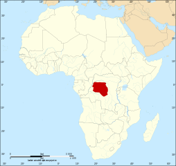
Map: Lambert azimutal equal-area projection, WGS84 datum, standard meridian: 15°E, standard parallel: 0° Scale: 1:15,000,000 |
| Date | (UTC) |
| Sourdant | |
| Oteur |
|
Licince
Ci fitchî ci est rprindåve sorlon çou k’ est dit divins licence Creative Commons Atribouwaedje – Pårtaedje avou les minmes accoirds 3.0 (non transposée).
- Vos estoz libe :
- di pårtaedjî – di rcopyî, di rispåde eyet di rdiner cisse ouve ci
- di rdjårber – di candjî ciste ouve
- Avou les condicions ki shuvèt :
- atribucion – Vos dvoz dner les racsegnes so l’ oteur ki vont bén, diner on loyén eviè l’ licince eyet mete si des candjmints ont stî fwaits. Vos ploz fé çoula di tote sôre di manires, mins nén tot djant ki l’ oteur vs aspale udonbén asprouve l’ uzaedje ki vos nd e fjhoz.
- pårtaedje a l’ idintike – Si vs candjîz u si vs eployîz ciste ouve ci po dnè fé ene ôte, vos dvoz mete vost ovraedje dizo l’ minme licince u ene licince ki va avou l’ cene di l’ ouve d’ oridjinne.
Journal des téléversements d’origine
This image is a derivative work of the following images:
- File:Africa_map_blank.svg licensed with Cc-by-sa-2.5,2.0,1.0, Cc-by-sa-3.0-migrated, GFDL
- 2011-07-14T19:50:24Z Sting 1525x1440 (698781 Bytes) Sudan/South Sudan 2011-07 border update
- 2009-01-10T20:36:44Z Sting 1525x1440 (710059 Bytes) Detail correction
- 2008-06-27T03:34:58Z Sting 1525x1440 (711453 Bytes) Completely new drawing with known projection
- 2006-05-31T15:28:42Z Sting 1390x1295 (571519 Bytes) Enhanced version : African and Asian continents separated
- 2006-05-31T03:53:32Z Sting 1390x1295 (566642 Bytes) {{Information |Description=Blank vector graphic map of [[:Category:Maps of Africa|Africa]] |Source=Several bitmap-type maps |Date= May 2006 |Author= Eric Gaba ([[User:Sting|Sting]]) |Permission=GFDL or CC-BY-SA |other_version
Téléversé avec derivativeFX
Istwere do fitchî
Clitchîz so ene date ey ene eure po vey kimint ki l’ fitchî esteut adon.
| Date/Eure | Imådjete | Grandeur | Uzeu | Comintaire | |
|---|---|---|---|---|---|
| asteure | 18 octôbe 2011 à 08:51 | | 1 525 × 1 440 (577 Ko) | Alphathon | == {{int:filedesc}} == {{Information |Description={{en|Map of the geographic distribution of bonobo's (''Pan paniscus'') within the African continent.}} Map: Lambert azimutal equal-area projection, WGS84 datum, |
Eployaedjes do fitchî
I n’ a nole pådje k’ eploye ci fitchî ci.
Eployaedje tot avå do fitchî
Les ôtes shuvants wikis eployèt c’ fitchî ci :
- Eployaedje so af.wikipedia.org
- Eployaedje so an.wikipedia.org
- Eployaedje so ar.wikipedia.org
- Eployaedje so arz.wikipedia.org
- Eployaedje so avk.wikipedia.org
- Eployaedje so azb.wikipedia.org
- Eployaedje so bg.wikipedia.org
- Eployaedje so bs.wikipedia.org
- Eployaedje so ca.wikipedia.org
- Eployaedje so cs.wikipedia.org
- Eployaedje so da.wikipedia.org
- Eployaedje so diq.wikipedia.org
- Eployaedje so en.wikipedia.org
- Eployaedje so en.wikiquote.org
- Eployaedje so et.wikipedia.org
- Eployaedje so eu.wikipedia.org
- Eployaedje so ga.wikipedia.org
- Eployaedje so gl.wikipedia.org
- Eployaedje so he.wikipedia.org
- Eployaedje so hi.wikipedia.org
- Eployaedje so is.wikipedia.org
- Eployaedje so it.wikipedia.org
- Eployaedje so ka.wikipedia.org
- Eployaedje so ku.wikipedia.org
- Eployaedje so lt.wikipedia.org
- Eployaedje so lv.wikipedia.org
- Eployaedje so nn.wikipedia.org
- Eployaedje so no.wikipedia.org
- Eployaedje so os.wikipedia.org
- Eployaedje so pa.wikipedia.org
- Eployaedje so pl.wikipedia.org
- Eployaedje so pnb.wikipedia.org
- Eployaedje so pt.wikipedia.org
- Eployaedje so ro.wikipedia.org
- Eployaedje so ru.wikipedia.org
- Eployaedje so sco.wikipedia.org
- Eployaedje so simple.wikipedia.org
- Eployaedje so sr.wikipedia.org
- Eployaedje so tl.wikipedia.org
- Eployaedje so tl.wikiquote.org
- Eployaedje so tr.wikipedia.org
- Eployaedje so uk.wikipedia.org
- Eployaedje so vi.wikipedia.org
- Eployaedje so www.wikidata.org