Imådje:Map-Germany-1945.svg
Le contenu de la page n’est pas pris en charge dans d’autres langues.
Èn årtike di Wikipedia.

Fitchî d’ oridjinne(Fitchî SVG, finté di 3 492 × 2 966 picsels, grandeu: 726 Ko)

Commons logo
Commons logo
Ci fitchî ci provént d’ Wikimedia Commons ; si pout i esse eployî divins des ôtes pordjets Wiki. Li discrijhaedje di si pådje di discrijhaedje låvå est håynêye cial ådzo.

Discrijhaedje

Discrijhaedje
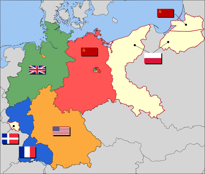
العربية: حدود المناطق المحتلة في ألمانيا عام 1957. الاراضي شرق خط نيس تحت السيطرة البولندية والسوفييتية، تظهر بلون ابيض. برلين منطقة مسيطر عليها من عدة بلدان داخل المنطقة السوفييتة.
English: Occupation zone borders in Germany, 1947. The territories east of the Oder-Neisse line, under Polish and Soviet administration/annexation, are shown as cream as is the likewise detached Saar protectorate. Berlin is the multinational area within the Soviet zone.
Français : Carte des zones d'occupation de l'Allemagne : le protectorat français de la Sarre apparait en blanc-crème, comme la Silésie, la Poméranie et les autres régions allemandes orientales annexées par la Pologne et l'Union Soviétique.
Deutsch: Grenzen der Besatzungszonen in Deutschland, 1947. Die Gebiete östlich der Oder-Neiße-Grenze, unter polnischer und sowjetischer Verwaltung/Annexion, sowie das Saar-Protektorat sind cremefarben dargestellt. Berlin ist ein multinationales Gebiet inmitten der sowjetischen Besatzungszone.
Date 17 måss 2008 (date de téléversement originale)
Sourdant Based on map data of the IEG-Maps project (Andreas Kunz, B. Johnen and Joachim Robert Moeschl: University of Mainz) - www.ieg-maps.uni-mainz.de.
Oteur User:52 Pickup
SVG information
InfoField
 
 
Cette carte W3C-invalide a été créée avec Inkscape.

Licince

w:fr:Creative Commons
atribucion pårtaedje a l’ idintike
Vos estoz libe :
  • di pårtaedjî – di rcopyî, di rispåde eyet di rdiner cisse ouve ci
  • di rdjårber – di candjî ciste ouve
Avou les condicions ki shuvèt :
  • atribucion – Vos dvoz dner les racsegnes so l’ oteur ki vont bén, diner on loyén eviè l’ licince eyet mete si des candjmints ont stî fwaits. Vos ploz fé çoula di tote sôre di manires, mins nén tot djant ki l’ oteur vs aspale udonbén asprouve l’ uzaedje ki vos nd e fjhoz.
  • pårtaedje a l’ idintike – Si vs candjîz u si vs eployîz ciste ouve ci po dnè fé ene ôte, vos dvoz mete vost ovraedje dizo l’ minme licince u ene licince ki va avou l’ cene di l’ ouve d’ oridjinne.

Journal des téléversements d’origine

Transféré de en.wikipedia à Commons par Broadbeer utilisant CommonsHelper.

La page de description originale était ici. Tous les noms d'utilisateur qui suivent se rapportent à en.wikipedia.
  • 2008-03-17 19:50 52 Pickup 3492×2966× (760290 bytes) Changes to fill and border colours. Made differences clearer between occupation zones and eventual territorial losses.
  • 2007-08-31 14:57 52 Pickup 3492×2966× (755561 bytes) New version: regions placed under Polish and Soviet administration now presented slightly differently (borders instead of colour fill), Saar colour now only slightly different to French zone (still needs some work)
  • 2007-08-10 09:50 52 Pickup 3492×2966× (751829 bytes) oops, now with fixed image size
  • 2007-08-10 09:47 52 Pickup 744×1052× (751774 bytes) {{Information| |Description= Germany in the aftermath of World War II: 1 September 1945 |Source= Based on map data of the IEG-Maps project (Andreas Kunz, B. Johnen and Joachim Robert Moeschl: University of Mainz) - [http://www.ieg-maps.uni-mainz.de www.ie
Annotations
InfoField
Cette image est annotée : Voir les annotations sur Wikimedia Commons

Légendes

Ajoutez en une ligne la description de ce que représente ce fichier
Carte de l'oocupation de l'Allemagne par les alliés de l'entente après le seconde guerre mondiale

Éléments décrits dans ce fichier

mostere

17 måss 2008

a pour cause français

У français

gigaoctet français

Istwere do fitchî

Clitchîz so ene date ey ene eure po vey kimint ki l’ fitchî esteut adon.

Date/EureImådjeteGrandeurUzeuComintaire
asteure1 decimbe 2017 à 04:37Imådjete pol modêye do 1 decimbe 2017 à 04:373 492 × 2 966 (726 Ko)SammimackUpdated flags and colours
3 djulete 2015 à 14:13Imådjete pol modêye do 3 djulete 2015 à 14:133 492 × 2 966 (728 Ko)LichaoshengNew 48-Star US Flag from File:US flag 48 stars.svg
3 djulete 2015 à 14:00Imådjete pol modêye do 3 djulete 2015 à 14:003 492 × 2 966 (742 Ko)LichaoshengReverted to version as of 18:46, 8 October 2008
4 fevrî 2012 à 15:19Imådjete pol modêye do 4 fevrî 2012 à 15:193 492 × 2 966 (742 Ko)AnonMoosReverted to version as of 18:46, 8 October 2008 -- Kaliningrad had quite different status and fate from that of East Germany proper...
20 djanvî 2012 à 19:44Imådjete pol modêye do 20 djanvî 2012 à 19:443 492 × 2 966 (742 Ko)Sammy pomponKaliningrado is occuped by USSR.
8 octôbe 2008 à 18:46Imådjete pol modêye do 8 octôbe 2008 à 18:463 492 × 2 966 (742 Ko)File Upload Bot (Magnus Manske) {{BotMoveToCommons|en.wikipedia}} {{Information |Description={{en|Occupation zone borders in Germany, 1947. The territories east of the en:Oder-Neisse line, under Polish and Soviet administration/annexation, are shown as white as is the likewise det

Li pådje shuvante eploye ci fitchî ci :

Eployaedje tot avå do fitchî

Les ôtes shuvants wikis eployèt c’ fitchî ci :

Loukîz di pus so l’ eployaedje totavå di ci fitchî ci.

Meta-dnêyes