
Imådje:West Germany 1956-1990.svg

Taille de cet aperçu PNG pour ce fichier SVG : 450 × 456 picsels. Ôtès fintés: 237 × 240 picsels | 474 × 480 picsels | 758 × 768 picsels | 1 011 × 1 024 picsels | 2 021 × 2 048 picsels.
Fitchî d’ oridjinne (Fitchî SVG, finté di 450 × 456 picsels, grandeu: 471 Ko)
Ci fitchî ci provént d’ Wikimedia Commons ; si pout i esse eployî divins des ôtes pordjets Wiki. Li discrijhaedje di si pådje di discrijhaedje låvå est håynêye cial ådzo.
Discrijhaedje


.svg)
.svg)
.svg)
.svg)
.svg)


.svg)
.svg)
.svg)


.png)
.png)


.svg)


.svg)

.svg)


.svg)
.svg)
.svg)
.svg)


.svg)
.png)


.svg)


.svg)
.svg)


.svg)


.svg)


.svg)
.svg)
.svg)
.svg)
.svg)
.svg)
.svg)
_cropped.svg)
.svg)
.svg)
.svg)
.svg)
.svg)
.svg)
.svg)
.svg)
.svg)
.svg)
.svg)
.svg)
.svg)
.svg)
.svg)
.svg)
.svg)
.svg)
.svg)
.svg)
.svg)
.svg)
.svg)
.svg)
.svg)
.svg)
.svg)
.svg)
.svg)
.svg)
.svg)
.svg)
.svg)
.svg)
.svg)
.svg)
.svg)
.svg)
.svg)
.svg)
.svg)
.svg)
.svg)
.svg)
.svg)
| Cette image a été retouchée, ce qui signifie qu'elle a été modifiée par ordinateur et est différente de l'image d'origine. L'image d'origine se trouve ici : Blank map of Europe 1956-1990.svg:
|
Licince
Moi, en tant que détenteur des droits d’auteur sur cette œuvre, je la publie sous la licence suivante :
Ci fitchî ci est rprindåve sorlon çou k’ est dit divins licence Creative Commons Atribouwaedje – Pårtaedje avou les minmes accoirds 3.0 (non transposée).
- Vos estoz libe :
- di pårtaedjî – di rcopyî, di rispåde eyet di rdiner cisse ouve ci
- di rdjårber – di candjî ciste ouve
- Avou les condicions ki shuvèt :
- atribucion – Vos dvoz dner les racsegnes so l’ oteur ki vont bén, diner on loyén eviè l’ licince eyet mete si des candjmints ont stî fwaits. Vos ploz fé çoula di tote sôre di manires, mins nén tot djant ki l’ oteur vs aspale udonbén asprouve l’ uzaedje ki vos nd e fjhoz.
- pårtaedje a l’ idintike – Si vs candjîz u si vs eployîz ciste ouve ci po dnè fé ene ôte, vos dvoz mete vost ovraedje dizo l’ minme licince u ene licince ki va avou l’ cene di l’ ouve d’ oridjinne.
Journal des téléversements d’origine
This image is a derivative work of the following images:
- File:Blank_map_of_Europe_1956-1990.svg licensed with Cc-by-sa-3.0
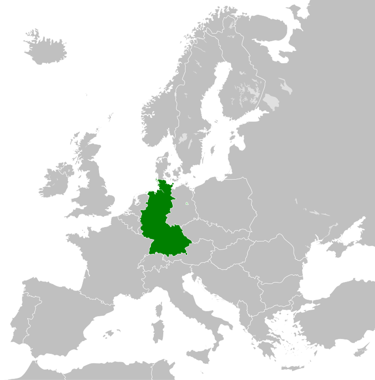
- 2011-10-30T04:43:42Z Alphathon 450x456 (485146 Bytes) == {{int:filedesc}} == {{Information |Description={{en|Blank map of Europe showing national borders as they stood from 1956-1990.}} |Source=*[[:File:Blank_map_of_Europe.svg|]] |Date=2011-10-30 04:42 (UTC) |Author=*[[:File:Bla
Istwere do fitchî
Clitchîz so ene date ey ene eure po vey kimint ki l’ fitchî esteut adon.
| Date/Eure | Imådjete | Grandeur | Uzeu | Comintaire | |
|---|---|---|---|---|---|
| asteure | 28 setimbe 2018 à 01:31 | | 450 × 456 (471 Ko) | FelipeRev | Se incluye Berlín Oeste pero con un color diferente, para marcar que pertenecía a su espacio económico |
| 15 djulete 2015 à 04:04 |  | 450 × 456 (476 Ko) | Elevatorrailfan | Breaking apart West Germany and West Berlin paths. | |
| 10 decimbe 2014 à 01:43 |  | 450 × 456 (476 Ko) | Elevatorrailfan | West Berlin was not part of West Germany. | |
| 26 nôvimbe 2011 à 00:39 |  | 450 × 456 (474 Ko) | StalwartUK | == {{int:filedesc}} == {{Information |Description={{en|Map of West Germany (Federal Republic of Germany) as it was from 1949-1990. Surrounding countries accurate from 1956-1990.}} |Source=*[[:File:Blank_map_of_Europe_1956-1990.svg|Bla |
Eployaedjes do fitchî
Li pådje shuvante eploye ci fitchî ci :
Eployaedje tot avå do fitchî
Les ôtes shuvants wikis eployèt c’ fitchî ci :
- Eployaedje so af.wikipedia.org
- Eployaedje so an.wikipedia.org
- Eployaedje so ar.wikipedia.org
- Eployaedje so ast.wikipedia.org
- Eployaedje so be.wikipedia.org
- Eployaedje so bn.wikipedia.org
- Eployaedje so bs.wikipedia.org
- Eployaedje so ca.wikipedia.org
- Eployaedje so cs.wikipedia.org
- Eployaedje so da.wikipedia.org
- Eployaedje so el.wikipedia.org
- Eployaedje so en.wikipedia.org
- Eployaedje so eo.wikipedia.org
- Eployaedje so es.wikipedia.org
- Eployaedje so eu.wikipedia.org
- Eployaedje so fi.wikipedia.org
- Eployaedje so fr.wikipedia.org
- Eployaedje so fr.wiktionary.org
- Eployaedje so ga.wikipedia.org
- Eployaedje so gl.wikipedia.org
- Eployaedje so gv.wikipedia.org
- Eployaedje so ha.wikipedia.org
- Eployaedje so he.wikipedia.org
- Eployaedje so hi.wikipedia.org
- Eployaedje so hr.wikipedia.org
- Eployaedje so ia.wikipedia.org
- Eployaedje so id.wikipedia.org
- Eployaedje so io.wikipedia.org
- Eployaedje so it.wikipedia.org
- Eployaedje so ja.wikipedia.org
- Eployaedje so ka.wikipedia.org
- Eployaedje so ko.wikipedia.org
- Eployaedje so ku.wikipedia.org
- Eployaedje so lij.wikipedia.org
- Eployaedje so lld.wikipedia.org
- Eployaedje so lmo.wikipedia.org
- Eployaedje so lt.wikipedia.org
- Eployaedje so lv.wikipedia.org
- Eployaedje so mk.wikipedia.org
- Eployaedje so ml.wikipedia.org
- Eployaedje so mr.wikipedia.org
- Eployaedje so ms.wikipedia.org
Loukîz di pus so l’ eployaedje totavå di ci fitchî ci.