
Imådje:Be-map.png

I n’ a nén di pus grande finté.
Be-map.png (559 × 600 picsels, groxheur do fitchî: 176 Ko, del sôre "MIME": image/png)
Ci fitchî ci provént d’ Wikimedia Commons ; si pout i esse eployî divins des ôtes pordjets Wiki. Li discrijhaedje di si pådje di discrijhaedje låvå est håynêye cial ådzo.

|
Cette image (de type locator map) devrait être recréée dans un format vectoriel, en tant que fichier SVG. Cela offrirait plusieurs avantages : voir Commons:Media for cleanup pour plus d'informations. Si une version SVG de cette image est déjà disponible, merci de bien vouloir l'envoyer. Après cela, remplacez ce modèle par {{vector version available|nouveau nom d'image.svg}}.
|
Discrijhaedje
| Discrijhaedje | Belgium map from CIA World Factbook (since 8 may 2006), converted from original GIF format |
| Date | |
| Sourdant |
CIA World Factbook |
| Oteur | United States Central Intelligence Agency |
| Ôtès modêyes |
|
.png)
Licince
Cette image est dans le domaine public parce que son contenu provient du World Factbook, édité par la Central Intelligence Agency des États-Unis d’Amérique.
|
 |
Derivative works
Derivatives of 2006 map:


Derivatives of 2004 map:


Derivatives of 2000 map:
-
 Belgie-mapa.PNG
čeština -
 Be-map-eo.png
Esperanto -
 Be-map-es.png
español -
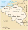 Be-map-fr.png
français -
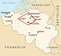
 Be-map-nl.png
Nederlands -
 Belgium-map-nl.png
Nederlands -
 Belgium üres.png
 -
 Ath in Belgium.png
 -
 Dendermonde location map.png
 -
 Vlaamse ruit.png


Istwere do fitchî
Clitchîz so ene date ey ene eure po vey kimint ki l’ fitchî esteut adon.
| Date/Eure | Imådjete | Grandeur | Uzeu | Comintaire | |
|---|---|---|---|---|---|
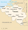
| asteure | 13 avri 2020 à 21:48 | | 559 × 600 (176 Ko) | Le Fou | Zeebrugge is not a city, but part of the city of Bruges. |
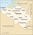
| 21 djulete 2018 à 19:13 |  | 1 024 × 1 099 (24 Ko) | Karel Adriaan | Resized to 1024 | |
| 20 avri 2007 à 20:48 |  | 328 × 353 (12 Ko) | Tene~commonswiki | Optimised (0) | |
| 11 måss 2007 à 17:07 |  | 328 × 353 (13 Ko) | Feydey | 2007 factbook map | |
| 27 may 2006 à 13:55 |  | 329 × 353 (20 Ko) | Matt314 | "Redu" in the same font size as the other cities | |
| 7 avri 2006 à 20:59 |  | 329 × 353 (20 Ko) | Abrev | Map of Belgium Updated version uploaded by [http://de.wikipedia.org/wiki/Benutzer:Tzzzpfff]. No rights reserved for updating. | |
| 5 djanvî 2006 à 16:46 |  | 330 × 355 (9 Ko) | Jrenier | Reverted to earlier revision | |
| 5 djanvî 2006 à 16:35 |  | 330 × 355 (9 Ko) | Jrenier | Reverted to earlier revision | |
| 3 djanvî 2006 à 19:53 |  | 330 × 355 (28 Ko) | Iunity | ||
| 27 nôvimbe 2004 à 19:24 |  | 330 × 355 (9 Ko) | Kneiphof | Map of Belgium, CIA factbook (taken from EN Wikipedia) |
Eployaedjes do fitchî
I n’ a nole pådje k’ eploye ci fitchî ci.
Eployaedje tot avå do fitchî
Les ôtes shuvants wikis eployèt c’ fitchî ci :
- Eployaedje so als.wikipedia.org
- Eployaedje so ay.wikipedia.org
- Eployaedje so azb.wikipedia.org
- Eployaedje so az.wikipedia.org
- Eployaedje so bcl.wikipedia.org
- Eployaedje so be-tarask.wikipedia.org
- Eployaedje so bg.wiktionary.org
- Eployaedje so bn.wikipedia.org
- Eployaedje so bs.wikipedia.org
- Eployaedje so ca.wikipedia.org
- Eployaedje so de.wikipedia.org
- Eployaedje so de.wikinews.org
- Eployaedje so dsb.wikipedia.org
- Eployaedje so en.wikipedia.org
- Eployaedje so en.wikinews.org
- Eployaedje so en.wikivoyage.org
- Eployaedje so en.wiktionary.org
- Eployaedje so es.wikipedia.org
- Eployaedje so fa.wikipedia.org
- Eployaedje so fi.wikipedia.org
- Eployaedje so fr.wikipedia.org
- Eployaedje so fr.wikinews.org
- Eployaedje so gag.wikipedia.org
- Eployaedje so ga.wikipedia.org
- Eployaedje so gl.wikipedia.org
- Eployaedje so ha.wikipedia.org
- Eployaedje so hi.wikipedia.org
- Eployaedje so hy.wikipedia.org
- Eployaedje so incubator.wikimedia.org
- Eployaedje so io.wikipedia.org
Loukîz di pus so l’ eployaedje totavå di ci fitchî ci.