Imådje:Breakup of Yugoslavia.gif
Le contenu de la page n’est pas pris en charge dans d’autres langues.
Èn årtike di Wikipedia.

Fitchî d’ oridjinne(1 545 × 1 242 picsels, groxheur do fitchî: 187 Ko, del sôre "MIME": image/gif, en boucle, 14 trames, 44 s)

Commons logo
Commons logo
Ci fitchî ci provént d’ Wikimedia Commons ; si pout i esse eployî divins des ôtes pordjets Wiki. Li discrijhaedje di si pådje di discrijhaedje låvå est håynêye cial ådzo.
This image could be re-created using vector graphics as an SVG file. This has several advantages; see Commons:Media for cleanup for more information. If an SVG form of this image is available, please upload it and afterwards replace this template with {{vector version available|new image name}}. It is recommended to name the SVG file "Breakup of Yugoslavia.svg" - then the template Vector version available (or Vva) does not need the new image name parameter.

Discrijhaedje

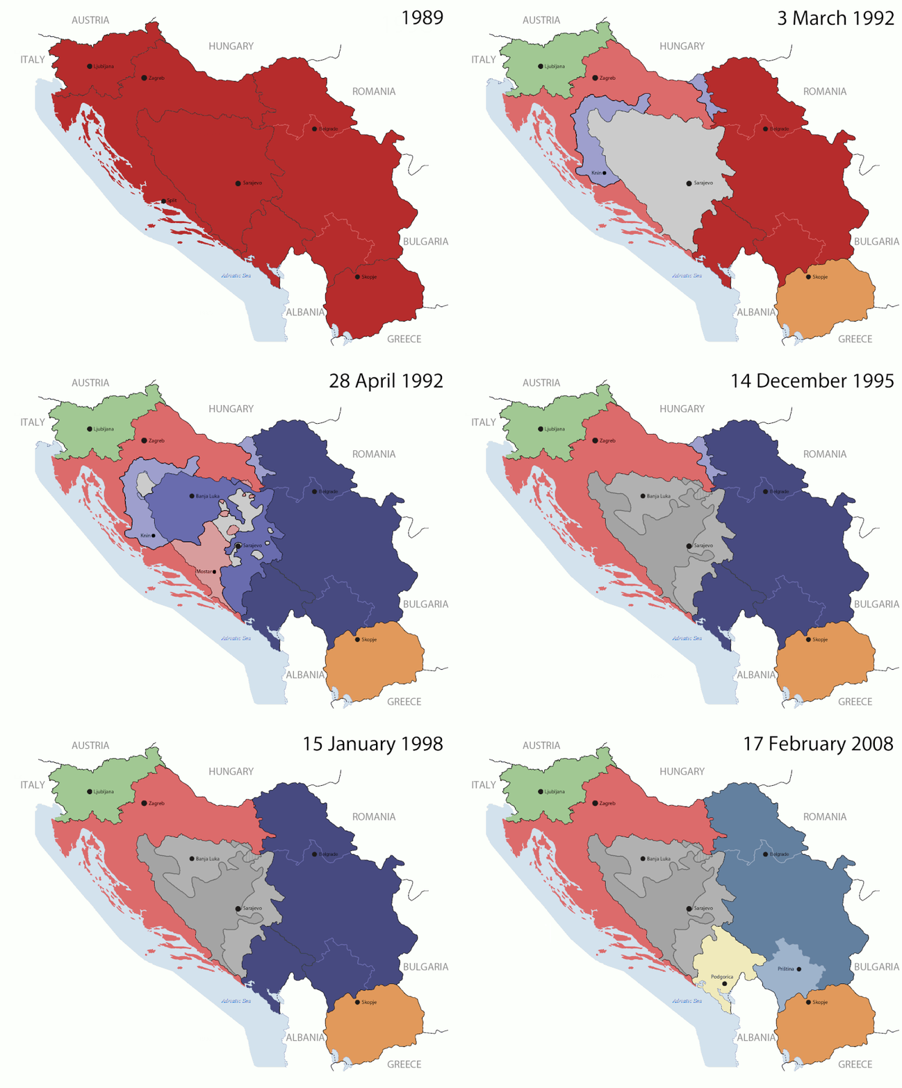
Key:

Yugoslavia (1943–1992) SFR Yugoslavia
Croatia (1991–present) Croatia
Herzeg-Bosnia (1992–1994)
UNTAES (1996–1998)
Federal Republic of Yugoslavia / Serbia and Montenegro (1992–2006) Serbia and Montenegro
Republika Srpska (1992–present) Republika Srpska
Serbian Krajina (1991–1995/96)
Republic of Bosnia and Herzegovina (1992–1995)
Bosnia and Herzegovina (1998–present) Bosnia and Herzegovina
Western Bosnia (1993–1995)
Serbia (2006–present) Serbia
Kosovo (under UNMIK control 1999–present; declaration of independence 2008) Kosovo
Montenegro (2006–present) Montenegro
Macedonia (1991–present) Macedonia
Slovenia (1991–present) Slovenia


Discrijhaedje

This is an animated GIF that shows the stages of the breakup of the SFR Yugoslavia in the 90's and 2000's. The map based off Morwen's map of the divisions of the SFRY, Which is licensed by the GFDL. The source for the dates of independence is the CIA World Factbook. These maps do not now show the Inter-Entity Boundary Line (IEBL) and/or the entities that are separated by it. The IEBL has been drawn based on this CIA map; the Brčko District has been drawn based on Image:BH municipality location.gif, by user:Ante Perkovic. I might add them in the future.

Since the original map was GFDL, this image is as well.

A map depicting Kosovo's final status is ready once it takes effect.


Changelog for versions 2/3:

Here are some changes in this new build of the map:

  • The Kosovo boundary has been given a shade of red instead of the previous UN blue since they are a province of Serbia under UNIMIK control.
  • Montenegro's color has been changed to a golden shade close to what's on the flag.
  • The IEBL and the Brčko District has been redrawn because I deleted the original map; the color for the Republika Srpska is lighter.
  • The dates are at the top left hand corner of the map instead of the bottom.
  • I have taken a new approach as to the boundaries. Each part of Yugoslavia now shows the boundary on the maps starting the year they broke away. I feel this change helps readers understand the breakup better.
  • The SFRY and the FRY are in different shades since the FRY was never accepted as the successor to the former by the UN.
  • The colors for the entities of BiH have been removed as to not confuse people into thinking that they are independent states. What remains is the IEBL with both entities in green.
  • The Kosovo boundary is finally in hash marks!
  • The Brčko District has been removed. The sale is too small to show accurately.

Changelog for version 4:

  • The map is larger!
  • The image has been rebuilt to include the eastern part of FYR Macedonia.
  • The image has been updated to take in Kosovo's new status.
  • The IEBL is now a darker line.
  • Montenegro, Kosovo, and FRY/SCG/Serbia have new colors!

Changelog for version 5:

  • Rebuilt
  • Larger map: size of base image
  • Accurate Inter-Entity Boundary Line
Date 24 July 2006 (orginal upload date)
Sourdant Made by Hoshie; see above for more details on sources.
Oteur Hoshie
Ôtès modêyes

Licince

GNU head Vos avoz l’ droet di rcopyî, di spåde et di rcandjî ci documint ci sorlon çou k’ est di dins l’ GNU Free Documentation License modêye 1.2 u les cenes d’ après eplaidêyes pal Free Software Foundation, sins hagnons nén candjåves, sins l’ tecse del prumire pådje di coviete eyet sins l’ tecse del dierinne pådje di coviete. Gn a-st on egzimpe del licince divins li hagnon k’ a l’ tite GNU Free Documentation License.
w:fr:Creative Commons
atribucion pårtaedje a l’ idintike
Ci fitchî ci est rprindåve sorlon çou k’ est dit divins licence Creative Commons Atribouwaedje – Pårtaedje avou les minmes accoirds 3.0 (non transposée).
Vos estoz libe :
  • di pårtaedjî – di rcopyî, di rispåde eyet di rdiner cisse ouve ci
  • di rdjårber – di candjî ciste ouve
Avou les condicions ki shuvèt :
  • atribucion – Vos dvoz dner les racsegnes so l’ oteur ki vont bén, diner on loyén eviè l’ licince eyet mete si des candjmints ont stî fwaits. Vos ploz fé çoula di tote sôre di manires, mins nén tot djant ki l’ oteur vs aspale udonbén asprouve l’ uzaedje ki vos nd e fjhoz.
  • pårtaedje a l’ idintike – Si vs candjîz u si vs eployîz ciste ouve ci po dnè fé ene ôte, vos dvoz mete vost ovraedje dizo l’ minme licince u ene licince ki va avou l’ cene di l’ ouve d’ oridjinne.
Ce bandeau de licence a été ajouté à ce fichier dans le cadre de la procédure de mise à jour des licences des images sous GFDL.

Légendes

Ajoutez en une ligne la description de ce que représente ce fichier

Éléments décrits dans ce fichier

mostere

créé par français

Valeur sans élément de Wikidata

type MIME français

image/gif

05ca2aefea8406b809968643552d5095c847a42f

méthode de détermination français : SHA-1 français

191 625 octet

durée français

44 sigonde

hauteur français

1 242 picsel

largeur français

1 545 picsel

Istwere do fitchî

Clitchîz so ene date ey ene eure po vey kimint ki l’ fitchî esteut adon.

(les dierins | les pus vîs) Vey (10 pus noveas | ) (10 | 20 | 50 | 100 | 250 | 500).
Date/EureImådjeteGrandeurUzeuComintaire
asteure17 djulete 2016 à 07:40Imådjete pol modêye do 17 djulete 2016 à 07:401 545 × 1 242 (187 Ko)מפתח-רשימהReverted to version as of 17:22, 21 August 2015 (UTC)
21 awousse 2015 à 17:22Imådjete pol modêye do 21 awousse 2015 à 17:221 463 × 1 158 (1,81 Mo)BraganzaReverted to version as of 03:57, 19 January 2010
21 awousse 2015 à 17:22Imådjete pol modêye do 21 awousse 2015 à 17:221 545 × 1 242 (187 Ko)BraganzaReverted to version as of 01:02, 19 December 2011
21 awousse 2015 à 17:15Imådjete pol modêye do 21 awousse 2015 à 17:15120 × 95 (3 Ko)Braganza03:57, 19. Jan. 2010
19 decimbe 2011 à 01:02Imådjete pol modêye do 19 decimbe 2011 à 01:021 545 × 1 242 (187 Ko)DIREKTORAdded details
27 djulete 2011 à 18:09Imådjete pol modêye do 27 djulete 2011 à 18:091 545 × 1 242 (170 Ko)DIREKTORSmall fixes
27 djulete 2011 à 17:28Imådjete pol modêye do 27 djulete 2011 à 17:281 545 × 1 242 (171 Ko)DIREKTORAdded UNMIK
27 djulete 2011 à 16:38Imådjete pol modêye do 27 djulete 2011 à 16:381 545 × 1 242 (165 Ko)DIREKTORDates for the last two frames.
27 djulete 2011 à 12:10Imådjete pol modêye do 27 djulete 2011 à 12:101 545 × 1 242 (149 Ko)DIREKTORLighter shade for country names
26 djulete 2011 à 16:59Imådjete pol modêye do 26 djulete 2011 à 16:591 545 × 1 242 (170 Ko)DIREKTORHigher res plus details
(les dierins | les pus vîs) Vey (10 pus noveas | ) (10 | 20 | 50 | 100 | 250 | 500).

Li pådje shuvante eploye ci fitchî ci :

Eployaedje tot avå do fitchî

Les ôtes shuvants wikis eployèt c’ fitchî ci :

Loukîz di pus so l’ eployaedje totavå di ci fitchî ci.

Meta-dnêyes